Feeds:
Posts
Comments

Archive for the ‘Hikes’ Category

spring in the desert

I’ve seen a bit of the interior West lately. The middle of March found me finishing up wolverine work in the North Cascades of Washington state. By early April, I had performed the reverse-migration of driving south to the Sacramento Mountains of southern New Mexico. To put it another way—I used to be 60 miles from the Canadian border, and I now find myself a hundred miles or so from Mexico.

To my surprise and chagrin, however, driving 2,000 miles southward has somehow pushed me backward into winter. Warm, sunny days in Washington and the balsamroot beginning to bloom, yet leftover snowbanks in New Mexico, sleet, and yes, yesterday morning—snow flurries.

storm, escarpment, and soaptree yucca

I suppose the elevation might have something to do with it. The Methow Valley sits at about 1800’, whereas Cloudcroft soars at 8650’. But still, it seems a little strange.

One of the pleasures of the desert southwest, though, is your ability to move. A 16 mile drive out of Cloudcroft drops one more than 4000’ into Alamogordo and the Chihuahuan Desert. Twelve miles south of Alamogordo is a quiet little piece of heaven called Oliver Lee Memorial State Park.

The park is nestled against the escarpment of the Sacramento Mountains, 12 miles south of Alamogordo, NM. There is something about the location—maybe it is the water flowing out of Dog Canyon—that seems to concentrate bird, animal, and plant life. On this day, sporadic rain scattered down on the park as heavy clouds lowered veils of rain down on the escarpment. It was beautiful and much better than sitting through the 4-6” of snow that was falling up top. And the birds were singing.

black-throated sparrow

By far the highlight of the day was wandering down the wash below the visitor center and catching two good looks at a male red-faced warbler in full breeding plumage. Not a common bird around these parts, and a striking bird.

Want a bird list? Here you go:

Oliver Lee Memorial State Park, April 23-24, 2010

Turkey vulture                                 red-tailed hawk

Sharp-shinned hawk                      white-winged dove

Mourning dove                                great-horned owl

White-throated swift                     black-chinned hummingbird

Broad-tailed hummingbird         ladder-backed woodpecker

Say’s phoebe                                     western kingbird

Violet-green swallow                    Chihuahuan raven

Verdin                                                 cactus wren

Rock wren                                          canyon wren

Ruby-crowned kinglet                  blue-gray gnatcatcher

American robin                               curve-billed thrasher

Warbling vireo                                 black-throated gray warbler

Orange crowned warbler            Virginia’s warbler

Yellow-rumped warbler              Townsend’s warbler

American redstart                         Wilson’s warbler

Red-faced warbler                          western tanager

Spotted towhee                               canyon towhee

Chipping sparrow                           black-throated sparrow

White-crowned sparrow             western meadowlark

Scott’s oriole                                    house finch

The second day at Oliver Lee was the hike up Dog Canyon, which I highly recommend. You get up into a canyon with high walls, and another watery section of canyon bottom just below where the canyon boxes out. Pretty there, with dripping water and maidenhair fern. I was hoping to find one of those places… you know, the pool-sized plunge pool below the pouroff… the place to ask a girl to marry you. But no luck. The hike is good though. You pass through several different ecological zones as you gain elevation, and get views of the desert and White Sands.

view of white sands from Dog Canyon

Oh yeah, and it is a historical spot. The visitor center is beside the ruins of a homesteader named “Frenchy” Rochas (1843-1894) who died under mysterious circumstances and did some impressive work with stone walls and irrigation. Nearby, too is the ranch house of Oliver Lee (1865-1941), a locally famous rancher and politician who even had a run-in with Pat Garrett. The book Tularosa is a good read about local history.

ruins of Frenchy's cabin

But all things must end. By the end of the weekend it was back up into winter at nearly 9000’. Someday soon the trees will leaf out, and it won’t be long until the mountain will be a pleasantly cool refuge from the blistering heat of the desert floor.

Read Full Post »

a peek toward Salt Creek

Peekaboo Spring is the end of the road. And I suppose I could have driven there, save for the fact that my truck was heavily loaded with belongings. Instead, I took a walk from Squaw Flat Campground and five miles later found myself at a trailhead, complete with parked trucks and loud visitors.

The biggest attraction of Peekaboo Spring is the rock art that graces a point of rock that sticks out into the drainage and forces Salt Creek to make a large U.  A line of painted dots and two white shield figures partly obscure older, faded, and more sinister figures painted in brown. People have been here a long time.

rock art at Peekaboo Spring

note the faint brown figures

A few hours later I found the perfect camp in a side drainage off of Salt Creek. Rain was predicted for the night, and I found a huge boulder with overhung space beneath it… large enough for my tent and I, and remarkably free of packrat tracks or droppings. There was a an arch high on the distant redrock horizon. My legs were tired and there was hours until sunset. I wished I’d brought a book. Life was good.

shade and rain shelter

morning view from camp

The next day was one of memories. At the top of the side canyon, I found the spot where, years ago, I found my first spotted owl. Well, in truth, she found me–whistled at me in full daylight. But that’s another story. But still, I found the tree and the exact spot where I had been standing. Fifteen years and nothing looked that different. I wouldn’t have been surprised to have found my boot prints.

And further down the canyon, another spot where I watched a mother owl feeding two fluffy owlets as morning light painted the canyon walls orange. A magical moment. I found that juniper, too. But no owls.

At one point in my wanderings, I noticed a line of white dots on a rock face… much like those at Peekaboo Spring. Further investigation yielded a couple of figures on another panel. One was a faded, white snake, and the other was a sheep or goat. This was one of my favorite finds of the trip. What does this Anasazi art mean?

a pointilist goat... sheep?

The end of my day was a reconnaissance mission to the very top of the side canyon to see if maybe, just maybe, I could find a route that would cut through back to Salt Creek Canyon. The map suggested the possibility, but I have been in this country enough to know that the contour lines can hide many a impassable wall. But it was worth a try.

Turns out there were several impassable walls. I studied the benches carefully, and saw a few places that might lead a seasoned climber/scrambler up, but in the end decided that backtracking was the better option. So much for a loop hike. I would have been doing my climbing with a fully loaded pack, and no one knew where I really was. Still, it was pretty country there–soaring red cliff faces and spires. And the attempt made me feel alive.

Day three found me hiding my big pack in Salt Creek Canyon and strolling up canyon carrying some water, food, compass, and the map. The higher parts of Salt Creek, just north of the Angel Arch side canyon, twist back and forth like a snake in the rock art (maybe there’s a connection…) and is beautiful to walk. Furthermore, the area around Angel Arch is full of Anasazi ruins and rock art. It makes for fantastic investigation. I climbed up to several rock art panels, and by glassing and re-glassing one rocky point, just caught the dark square of a doorway–this little site was amazing…little cobs of corn still in the granary, and five hand outlines above the structure.

granary and hand outlines

1200 year old (?) corn cob

On my way back down, I scrambled up to a white outline of a hand and forearm. I was a little disappointed that there weren’t any other panels or rock art near it… but then I noticed some piled, flat rocks that looked like a collapsed structure, and in among these I found some pottery shards. I’ve never found pottery shards before, and it was pretty cool. Laying in the dust, little pieces of something made by those same hands that I see outlined in white paint in secret places in these canyons. How many years old?

pottery shards

The last day is always hard. Tiredness is a factor, of course, but the brain also tends to wander. Thoughts of real food, cold drinks, and other facets of syphillization intrude on the part of you that is able to appreciate the present. You are still outside in beautiful country, the mountains still shine with snow, and red rocks reach toward and endless sky, but somehow the mind wanders. It’s inevitable. But even though it is a relief and joy to see the truck at the trailhead, it still saddened me to leave the canyon country. Good memories, good adventures. It’s funny how a place can feel like home.

Sad to part, but I’ll be back.

Read Full Post »

Island in the Sky

view from my camp near Salt Creek

Well, I sat down over the last few days to write up a bit about my visit to the backcountry of Needles District, Canyonlands National Park, and to my surprise, what was going to be a quick write-and-post has turned into a 3000 word or more behemoth. So instead of unloading a novel on you poor innocent (ADD?) readers, I thought I would try a quick post that consisted mostly of pictures.

On a long drive from Washington to New Mexico, I set aside five days to revisit Canyonlands NP, and, in particular, to head into the backcountry of the Needles District and hike Salt Creek Canyon. I’d worked in the park in 1995, and had told myself that if they ever closed the 4WD road going up Salt Creek, I’d like to come back and hike it. Fifteen years later, the opportunity presented itself.

But first, Island in the Sky. I pulled into Moab and immediately booked two nights at the Lazy Lizard Hostel. The place had changed a little in 15 years, but is still much the same. Can’t beat a $7 tent site within walking distance of downtown. And I couldn’t get a hotel room if I wanted one. F#%^@*g  jeep safari weekend. Again. Every time I come through Moab there is an abundance of testosterone and oversized, gas-guzzling toys in town. Note to self–next time Monticello.

But anyway, I was talking about Island in the Sky. It’s a great place to barely get out of your car. Or in my case, to kill a few hours before spending the night at Eddie McStiff’s and Woody’s. It’s a big mesa with expansive views…

a view from the island

the white rim

edge of the world

After a few short walks to overlooks, and hiking from Grandview Point out toward Junction Butte (highly recommended), I turned the truck away and headed back toward Moab, and the adventure waiting for me at the Needles District…

Read Full Post »

Farewell to an Old Friend

In 1995, just graduated from college, my father was kind enough to buy me a pack as I looked forward to a trip West and the first step of my after-college life–a job surveying for Mexican spotted owls in southern Utah. It was an expedition-size Lowe Alpine pack that turned out to be much bigger than I needed for the work. As I recall, I was also wearing a pair of work boots that weren’t exactly suited, either. I must have been quite a sight.
A friend on the owl crew had a Kelty Redwing pack that seemed good and he raved about it. So I bought one. Dark blue, internal frame, and plenty of zipper access. Convenient side pockets for water bottles. I wore it that season, and the next, and the next… It experienced the heat, dust, and violent storms of Utah and Arizona. And kept going…
It struggled through high alpine spruce in Vermont, experienced the open pines and thorny underbrush of Mississippi, felt the fall of exhausted spring migrants on the delta in Louisiana, fought the heat and snakes of lowland Arizona, watched whales surface and blow from Santa Catalina Island in California, and carried fall hawk data in Colorado and Washington.
At some point in these journeys I tried to replace it with a smaller REI pack and immediately returned to the trusted Kelty. When I started bird surveys in the ponderosas and Doug firs of eastern Washington, I bought a newer version of the Kelty Redwing (on sale) with newer features– a hydration pouch, built in stretch cords, and even a key clasp and pencil slots in a pocket. But the side pockets were too small for a water bottle, and the pack just didn’t fit the same.
By now one of the aluminum stays had poked through the top of old reliable, which I clumsily repaired with a gob of seam sealer. The main zipper was catching at times despite attempts at lubrication. But still it kept going. Birds in Washington. Four winters of snow-tracking lynx. Two seasons of spotted owls in New Mexico. Even a stint in Alaska.
But a week ago, while carrying gear to check wolverine traps, the main zipper gave way and wouldn’t come back. A fatal injury. And yet the Kelty still sits in the mud room. It’s hard to say goodbye.
Why is it that things can hold such power? It’s nylon and padding and metal surely have no soul… but yet there is so much of my sweat, dirt, and even blood ingrained in it that it almost feels a part of me, or at least like an old friend.
And I suppose I could find a way to repair the zipper, but how long until something else gives out. At some point I have to let go. And so the time comes to unshoulder it finally and say goodbye. And with it goes a little part of me.

Read Full Post »

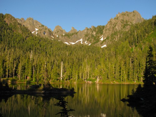
Flapjack Lakes, photo by DMH

It wasn’t until mid-afternoon on the 4th that I suddenly realized it was a holiday. Camping has a way of doing that to you. But I was on my way out. Each step bringing me closer to a truck, to cell service, to stores with cold beer, and yes — to fireworks.

I almost didn’t go. Late night on Wednesday, after a full 10 hours of work, I was losing enthusiasm. Thursday morning, with an alarm going off early, I nearly decided to call it off. But what else was I going to do with a four day weekend? By the time i reached the Staircase Ranger Station (a building the size of a two car garage), I could feel a smile blooming. The ranger was kind and informative, and my walk-up reservation of a second night for me and a tent was no problem. I paid my wilderness camping fee. I paid my park entrance fee, and i was ready to go.

You see, taxes aren’t enough. Public access to public lands isn’t free. If you are going to recreate, you better have the money to back it up. Ah well, a diatribe for another day. Altogether though, it cost $24 for two nights and three days in Olympic National Park. I could easily spend that in one night at the bar.

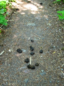
Smelly effluent, photo by Daniel HarringtonAnd apparently the money gets put to good use. The North Fork Skokomish trail, which I followed for 4 miles before departing upward toward the high country, is a highway. Two horses could pass by each other without even touching with a flash of tail. And apparently they do. Within minutes of taking to the trail, i was dodging gooey gems of horsiness all along the trail. At least the smell drifts around enough that you usually get a warning to look down before a squishy encounter. People, of course, have to bury their shit at least 6 inches deep and 200 feet from a water’s edge. But the horses have no such restrictions in the park. No diapers needed. Hikers beware. Noble beasts, smelly effluent.
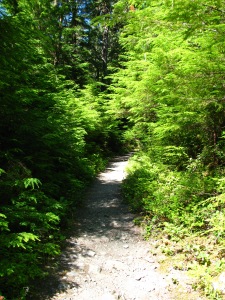
North Fork Sykomish River Trail, photo by Daniel Harrington

The North Fork Skokomish River Trail Highway winds its way along a thin strip of land between the river and the steep face that plunges down from the heights to connect high country to low. The river looks cold, and as though there is a hidden power in it. There is evidence to support this hunch, too. The sleeping river winds through a wide flat of cobbles and boulders and logjams that speak of a different beast at high water. Strong enough to carve down mountains and leave steep slopes to the side. A patient power that erodes. And, judging by the snow lingering in the heights, cold. Powerful enough to sweep old-growth logs along for the ride.

For the first little bit i was wrapped in familiarity. A trail underfoot. Old, worn boots. A faded and ripped pack filled with various implements that remind one of the true simplicity of human need. A sleeping bag. Some food. A pot and fry pan. A little stove (no fires above 3500′!). How many times? How many trails? Every turn and straight in the trail seemed to remind me vaguely of somewhere else. The Methow River. The Grande Ronde. War Creek. Steep slopes on one side, occasionally spilling slides of rocks over the trail. Side creeks carving a U in the trail. A hot breeze descending from the bare slopes left by the Beaver Fire of 1985. Familiar flowers.

After a mile or so on the park highway, the pack began to remind me of the complications of human need and decision making. This was my first overnight backpack of the season, and as such i had brought too much stuff. Camp soap? Who really needs that? Deoderant??? Was i really going to eat all that food? My legs began to remind me that every ounce counts over the course of lugging my life into the high country. And i wasn’t even to the steep part yet.

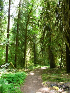
N Fork Sykomish River Trail, photo by Daniel HarringtonThe lowland forests of western Washington are cloaked in life. Heavy moss hangs from bigleaf maples. Huge trunks send branches into the heavens to shade out the lower creatures. Ferns and moss everywhere. There’s not a place where sunlight hits bare ground. Except of course for this trampled trail worn down to rock and dry dirt. But the world changes with each step upward.
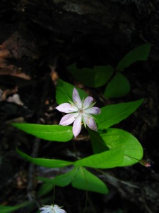
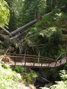
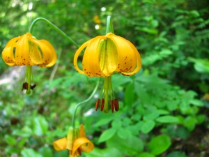
At 4 miles, i reached the trail junction that would start me on a course to climb straight up into it. The halfway mark in miles, but only 500′ gained in height. 1500 more to go. A few steps onto the Flapjack Lakes Trail and there was already a marked change. The trail was a simple footpath, replete with obstacles and overgrown vegetation. Much more like it. And it was my pleasure to read a sign — “No Stock.”

I won’t bore you with the details of the climb. Of how hemlocks gave way to Doug fir and cedar, or of all the interesting flowers along the way. Or how i left the rising flutes of Swainson’s thrushes down below for the whistle-and-flute of hermit thrushes up high. There were some creek crossings, and a mistep or two. And a lot of sweat. By the time i crested the trail and found a lake in front of me i was ready for a cold beer. Now there’s something i should have brought.

Camp soap — really?

broad-leafed starflower

broad-leafed starflower

the bridge at Madeline Creek

the bridge at Madeline Creek

tiger lily

tiger lily

Read Full Post »